Point to Point Blog
Sunday, June 27, 2021
Day 20
Last night I was tied up on a long, sandy beach. I noiced around dark that the river seemed to be dropping leaving more of the boat "beached". I decided to stick a broken branch in the sand at the river's edge. That's when it became obivious that the river was in fact dropping. Yesterday morning as I pulled in my anchor it somehow became unsnapped, which meant I didn't have an anchor and the option of anchoring farther away from shore. So I decided to stay awake all night and keep checking the river level. Also, everytime a towboat passes by during the night it creates wakes that can turn my boat sideways and push it up against the shore. I usually prevent this by anchoring from the side, but without an anchor I had another reason to stay up all night. As it turned out I did need to repeatedly get out of the boat and keep moving it back. By morning the boat was approximately twenty feet from where I originally tied up.
My first picture of the day was the Zimmer Power Station in Moscow, Ohio.
I was going to stop at New Richmond, but the Showboat Majestic that used to be moored on the Cincinnati riverfront is blocking the New Richmond visitor dock and steps. The Majestic is looking pretty poorly compared to its glory days.
This morning was early Sunday and I passed by several groups of boats still tied together from yesterday's partying.
This is the I-275 bridge out by Coney Island.
I knew I needed just a little more gas to get to my final destination and I've stopped at this place, the Aquaramp, before. As I approached the dock three people came out to hold my boat and help me get gas, ice and snacks.
A group of women got off this CinnyCycleBoat just as I passed by. I've seen the mobile bars where everyone sits around a bar and pedals as it moves through town. This one was the same concept, except it was on water.
Here are a couple of paddlewheelers I passed on the Kentucky side of the river. One was loading up Cincinnati Reds fans to go over to the ballpark.
Here are a couple pictures of the Cincinnati Skyline and Bengals stadium.
As I approached Saylor Park, I saw this floating house and the Official Fireworks Barge of the Cincinnati Reds. I didn't even know they had an official barge.
This is the tomb of William Henry Harrison as seen from the river. In the days of the paddlewheelers they would blow their whistles in passing as a tribute to the fallen President of the United States.
Everything went pretty well today up until I was about a mile from my final destination. Just as I passed Lawrenceburg, Indiana I saw rain approaching that was so heavy I couldn't see the river or shoreline. I headed straight for the Indiana shore, attached a line to the front of the boat and held it against the shore till the rain passed. I got soaked as heavy rain and lightning was happening all around me. After the storm I stopped at the confluence of Tanners Creek and the Ohiu River so I could take down my mast. Then I continue up the creek to the lanch ramp where Denise was there to meet me.
Today was Day 20. I covered 54 miles.
Saturday, June 26, 2021
Day 19
Today I got started at 6:20, which is my earliest start. My first start was Manchester, Ohio for ice, gas and food.
Next stop was Maysville, Kentucky. I really didn't need anything, but they have a very welcoming area along the riverfront.
Maysville's floodwall features murals by Robert Dafford, who isn the same artist as did the murals in CIncinnati. One addition to the murals, which doesn't look like Daggord's work, are a couple related to Maysville's most famous citizen, Rosemary CLooney.
I passed by Ripley Ohio.
I spoke with these two gentlemen who are paddling a canoe the entire length of the Ohio River.
This was my campsite for the evening. It's a long sandy beach at least a mile from the closest residents.
Friday, June 25, 2021
Day 18
First thing this morning I crossed the river and headed downstream to Huntington, West Virginia's riverfront park. The restrooms were open and clean. but like most cities and larger towns they, don't have much in the way of things that would help traveling boaters. Their gas stations and convenience stores are blocks away. I walked through the opening in the flood wall, but then turned around and returned to the boat.
After leaving Huntington I passed through an area with a lot of towboats and barges. This is called a fleeting area and it's where the towboats and barges are stored or lined up for shipping.
Next stop was Ironton to get supplied. Many of the smaller cities like to share their history. Ironton does with with huge murals on their floodwalls. The mural in the photo says Ironton has the oldest Memorial Day Parage in the country, begining in 1868.
I passed under this brige in Sciotoville. Its the largest riveted truss bridge in the United States. Although built in 1916, it's still consudered an enineering marvel.
I was supposed to get gas in Portsmouth, but the gas station that use to be near the river is no longer there.
Mark Redden went all through school with my son and was in Cub Scouts with him as well. Mark now lives in the area I was passing through today. He saw on Facebook that I was on this adventure and sent me a message that if I needed help I could give him a call. He also came down to the river as I was passing by and took these pictures.
My last stop of the day was Vanceburg, Kentucky to get gas. Two people volunteered to give me a ride to the gas station, but Dean was the first. As it turnd out, Dean is the mayor of this friendly little town.
Thursday, June 24, 2021
Day 17
NEARLY A CATASTROPHE!!!
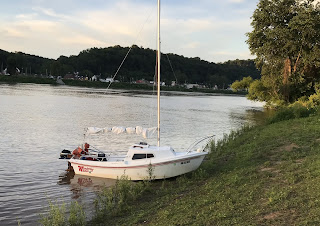
Yesterday's blog ended with this picture of my boat shored along the edge of a community park. It looked like a good place to stay. I went to bed in the boat's cabin at about 11:00 that night. Throughout the night I noticed that while in my sleeping bag I kept sliding toward the back of the boat. At 4:30 in the morning I woke up to see a bright flashlight shinning on my boat from a distance. I figured it was the police investigating why my boat was tied up there. I opened the door and stuck my head out. I said, "what's up?" The guy with the light on his head said, I'm sorry....I'm just bow fishing....I won't bother you". Then he said, "Do you need any help?", which I thought was a strange question, but then I looked around me and realized the boat was completely out of the water. Not only that but the back of the boat was a foot from edge of the river. It was then I realized the river had dropped 2 1/2 feet between 11:00 at night till 4:30 that morning. For all I knew the river was going to continue dropping, so I hurriedly got out of the boat to see if I could push it in the river. I wasn't able to move it more than half a foot and the back of the boat was acting like a bulldozer blade pushing mud into a pile and hitting big rocks used to keep the river bank in place. I wasn't sure what to do so I started looking up marine towing services. The closest one was 35 miles away and didn't open for three more hours. Anout then the bow fishing guy came back and I said "hey, can you help me push the boat back in the water?" He got out in the mud with me and we stared moving the bolders, then used our hands to scoop the mud away from the back of the boat. After more pushing and rocking, we finally got the boat slid back in the water. I offered him money, but he didn't want to accept it, but I insisted and gave him $200.00 because it would have cost me a lot more than that if I had to pay somebody to tow it. He said he was recently laid off of his job and the money was going to help him out a lot.
After getting everything back in the boat, I did what I'd planned to do which was to cross the river to a McDonald's that has a dock. I spent a good bit of time cleaning up mud and reorgazing the boat before going up to get an Egg McMuffin.
My next stop was Point Pleasant, West Viginia.
Point Pleasant has a courtest dock, riverfront park and an opening in their floodwall so boaters can visit town.
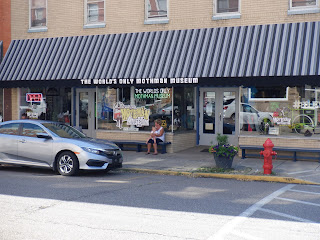
Point Pleasant is also home to that wonderful urban ledgend....Mothman". I toured the museum.
The next stop of the day was Gallipolis.
Gallipolis is another boater friendly town that has services nearby and a beutiful community park.
I ended my travels today with this baby beaver at the site where I'm camping. Mother and father beaver took off down the river, leaving their baby behind. He (or she) didn't seem to be too afraid of me and even swam right up to my boat. According to some folks I met here, it's not unusual for parent beavers to leave their babys alone for hours at a time. Today I finished up at mile 307 and covered 57 miles. I'm right at the edge of Huntington, West Virginia, but camped out on the Ohio side of the river.
Wednesday, June 23, 2021
Day 16
After working my boat out of last night's campsite, I traveled 12 miles downstream to Parkersburg, West VIrginia. Denise and I are familiar with Parkersburg because we've attened their Paddlefest event twice.
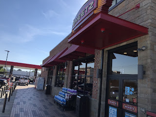
At Parkersburg I was able to walk a block and a half to Sheetz for ice, gas and lunch to go.
As I was getting back to my boat I saw a paddlewheeler headed for where I was tied up. I hurried up and got out if the way. The paddlewheeler takes people to Blennerhassett, Island which is both a park and has historic buildings on it to tour.
The area of the river I was in today is remote, but beautiful!
I saw a lot of debris in the river today, but upon arriving at Belleville Lock and Dam I was afraid I wouldn't make it into the chamber. I had to rock the boat back-and-forth to get it through.
My next stop was Ravenswood, west Viginia. They have a nice little park with a courtesy dock, but as you can see someone's boat recently caught fire there. At the park is a restored lock house and a mobile barbeque operation called "Sisters". I highly recommend the pulled pork sandwich.
The three guys fishing in this photo where in the only non-commercial boat I've seen the past three days. Due to heavy rains the river is especially muddy and running fast.
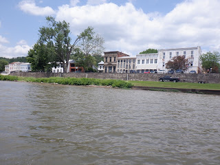
Tonight I'm camped along a city park in Mason, West Viginia. It's right across from Pomeroy, Ohio. Pomeroy is built between the river and a solid rock "mountain". They have two one way streets running through town with cross streets connecting them each block. Pomeroy has the dustiction of being the only incorporated community in the coutry to have no four way intersections.....the town isn't wide enough to have any!
Subscribe to:
Comments (Atom)


