Wednesday, July 29, 2020

DAY 12

Today was mainly a travel day with little opportunity for pictures or meeting people. There just is not much to do along the lowest portion of the Ohio River. 

I locked through Olmstead Locks and Dam......the last of twenty lock and dams on the Ohio and the last dam from here to the Gulf of Mexico.


As I left the lock, the lock master told me it looked like I was headed toward a storm. Sure enough, dark clouds, lightening and heavy rain were headed my way. So I hooked up the tarp and tied the boat up to a tree. I must have done a much better job today because despite pretty heavy rain, I stayed dry.


The Ohio River at Cairo is designated a "fleeting area" for barges. There are literally hundreds of barges parked along both shores as well as mid river. While navigating around the barges, you have to keep an eye on the many towboats working to line the barges up in the correct order..

As I was passing along side the City of Cairo, I saw a workboat going from the public boat ramp to mid-river. They were dumping five gallon buckets of some kind of bloody looking mixture. I could even smell it. Closer to the ramp I realized I was passing through some of the stuff. It looked like the guts from slaughter pigs or cattle. From the look of the boat being used, I'm assuming this was related to the commercial fishing operation in this area. However, this scene eliminated this boat ramp as an area I wanted to stay until my son could pick me up.

As I continued onward I saw all kinds of businesses supporting the towboat industry, from dry-docks to welding to work boats.

The picture above is of my approach to "the point. The water on the left is the Mississippi River and the water on the right is the Ohio. The exact "point" is where the little red and green placard rests on shore. As I beached the boat at the point and hopped out, I sunk over a foot in the mud.


It took about thirty seconds to pull my feet out of the mud for every step. I couldl't tie up the boat, so if it has started drifting away I never would have been able to run to catch it.

This is a photo of my boat beached at the point. When I was here years ago there was a sidewalk all the way to the water's edge so people could come down right to where the rivers meet. Now you can't get within fifty feet without sinking in.

As I re-boarded my boat and pulled away from the point, I took this photo. The bridge on the left is over the Mississippi River and the one on the right is over the Ohio. Although the Ohio River is twice as wide as the Mississippi up to this point, the Ohio is still considered a tributary to the Mississippi.


I continued down the Mississippi River to a nice little community called Wickliffe, Kentucky. They have a nice boat ramp located in their community park a couple blocks from local stores. A nice gentleman by the name of Robert drove me to one of the stores so I could get drinks and food while I waited for my son to arrive for the drive home. While waiting I saw this tow going up river. Tows on the Ohio are limited to three barges wide by five barges long (because of the locks). However, with no locks on the lower Mississippi the tows can be much larger. This one was three wide by seven long......that's twenty-one barges. They were being pushed by two matching towboats.

My son arrived around 9:30pm. As we were hooking the boat to the trailer and getting things packed away, I took a picture of this varmint  sitting on my boat.


Tuesday, July 28, 2020

DAY 11

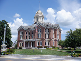
I left Rondeau Island and crossed the river toward Golconda, Illinois. This is a photo of their no longer used lock master house for Dam #51. This lock house is unique because of the castle style lookout tower on the right side of this photo.


The river was very calm, punctuated only by my boat and outboard motor. I saw no pleasure craft for the first five hours and only one towboat.

I saw several beautiful houses high on hills overlooking the river valley.


The day was overcast, but I saw dark clouds moving in. As I approached Paducah, Kentucky I couldn't see their bridge because the rain was so heavy. Since the rain had not reached me yet, I beached the boat, tied up on shore and I had time to arrange a tarp over my cockpit (as I had practiced at home). 

The tarp kept me relatively dry up until a towboat passed out in the main channel. I couldn't even see the towboat, but the wake came crashing against the back of the boat causing it to line up parallel to the shoreline. That meant the boat was leaning over quite a bit and subsequence waves from the wake were splashing into the boat.

Since the last time I was in this area, the City of Paducah has installed a transient ramp for boaters. It has water, electricity, a pump-out station and gas pumps. I just needed a place to tie up while I went into town and ate lunch.

The increasing width of the river is evident in the bridges. Earlier in my trip bridges may have been one, two or three spans. This bridge, down river from Paducah, is ten spans long.

This is how I tied up most evenings. A bow line (the front of the boat) is attached to an anchor pulling toward the middle of the river. A stern line (back of boat) is tied to a tree or some other anchor.

A photo of my evening view illustrates the width of the river at this point. It's more than a mile across. With only one downstream dam and virtually no development, this portion of the river is said to look much as it did when explored by Lewis & Clark. Because of the width, the water spreads out and areas become shallow; so shallow in fact that a hundred years ago farmers could walk their livestock or pull their wagons across the river. Today the shipping channel is dredged and maintained, but boats going away from the channel can be easily grounded.

Throughout the night I could hear towboats passing by on the other side of the river. By the time the wake reached me, it just gently rocked my boat. With no lights of any kind around, the lights of the towboats looked as bright and crisp as I've seen. The little blue object in the dark photo is a towboat from about a mile away.

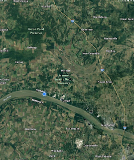
Once again I’m in a area with very little cell strength, so could not update the blog until later. I’m past Metropolis, Illinois close to a little community called Joppa and the widest part of the Ohio River. I travelled 52 miles today.

Monday, July 27, 2020

DAY 10

I spent the night camped out on the Kentucky shore right above the John T. Meyer Lock and Dam. As I was putting everything back in order for today's travels I noticed a single towboat without barges headed toward the locks. I hurriedly got my boat underway and radioed the lock master that because of last night's backup I had to camp and wait until morning. He told me to hold on a minute, then radioed the captain of the towboat asking if it was alright if I locked down with him. The captain okayed it, but we still needed to wait for the tow already in the chamber to be locked down.

This is a unique photo because I'm in the lock chamber with a towboat as the doors are closing. We were instructed to tie off at opposite end of the chamber. Not counting last night's delay, it took two hours to lock through the John T. Meyers Lock & Dam. Its been taking about a half hour to get through the previous locks.

People have cautioned me about the wake created by towboats, but I haven't found that to be a problem. The smallest wakes are from passing bass boats. They're usually going so fast they are essentially hydroplaning which doesn't produce much wake at all. The next biggest wake is the pleasure boats because they are going fast, but not hydroplanning. Tow boats with barges have the next largest wake, but it tends to be rolling and widely spaced. As long as smaller craft go over the wake at a 90 degree angle, towboat wakes are not a problem (unless you're right next to the towboat). Some of the most disruptive wakes are cause by passing houseboats. They sit lower in the water, thus displacing a large amount of water resulting in bigger wakes at a greater frequency. The worst wakes of all are produced by regional towboats working locally like the one in the picture. They're usually lining up or moving barges around for loading or unloading. As they leave a barge to go to the next, their front ends are like bulldozers pushing a large amount of water in front that rolls off to the sides like mini tidal waves. If one of these wakes hits a small boat from the side, it can tip over.

For about an hour this morning the river got very choppy.


I passed through areas today with beautiful rock formations. Some of these areas look more like an ocean setting than something you'd see along the Ohio River.


I saw lots of houses built on the rocky "cliffs" along the river.


On my previous kayak trip I stopped at this little community of 350 people known as Cave in Rock, Illinois. The town got its name from the cave in the rock that can be seen from the river. The cave area is now a state park and the cave itself has an interesting history. It was used as a base for river pirates, which was a problem on the Ohio and Mississippi Rivers in the late 1700s to mid 1800s. The History Channel had an episode on river pirates and includde Cave in Rock. The cave was used in several scenes in the 1962 movie, How the West Was Won. For seven years it was the Gathering of the Juggaloos site (see Insane Clown Posse). Cave in Rock has also been included in a wide variety of artistic and literary creations. The state of Illinois operates a free fairy on the river here. The restaurant I wanted to go to has been converted to a church and the tavern in town that has food was only filling call-in orders due to Covid 19.


I grew up and lived most of my life in the small community of Elizabethtown, Ohio. Today I stopped at Elizabethtown, Illinois. They have a floating restaurant that was the culinary highlight of my trip. Most people don't realize there are a substantial number of commercial fishing operations on the Ohio River. One such operation is attached to this restaurant. So the catfish meal I ordered was guaranteed to be fresh. If you're ever in this area, I'd suggest you go out of your way to stop here.


At the end of day 10 I am camped at the lower end of Rondeau Island, a remote location between Kentucky and Illinois. The closest community is Golconda, Illinois. I travelled 56 miles today.

Sunday, July 26, 2020

DAY 9


The first photo is of the Evansville, Indiana skyline this morning as I left the marina at 6:50. The marina I stayed at is where the LST World War 2 Landing Craft was located when I last visited. The LST is now located downtown


I knew Henderson, Kentucky has a large Methodist church so I stopped to attend service. From the sign on the door I found out all of their services are now online due to covid.

This is a red buoy. They mark the shipping channel in the river. When going downstream you stay to the right of the red buoys.


This is a green buoy. They mark the shipping channel in the river. When going downstream you stay to the left of the green buoys.

Staying between the buoys sounds pretty simple. Yet I wasn’t paying attention and grounded my boat in the middle of the river. So I got out of the boat and had to push and pull it over a pretty good distance until I could get back in and use the outboard to get in the main channel. This same thing happened on my kayak trip. You would think I’d have learned my lesson.


Mount Vernon is last city in Indiana I’ll pass on the river. I stopped here, as well as Henderson, Kentucky to get ice and drinks.

My plan was to stay near Uniontown, Indiana tonight, but I still had plenty of daylight left so decided to move on. A few miles downstream I came to the John T. Meyers Lock and Dam. I identified myself and requested permission to lock down. The lock master said there was a four hour wait. Apparently the 1200 foot chamber broke down. So they have to lock the large tows by breaking them down and passing sections through the recreational lock. I decided to tie up on the Kentucky side for the night and will try to lock down in the morning.

I travelled 55 miles today.

I thought I’d share some modifications I’ve added to the Wandering Wisp to make the trip a little more efficient.

I’ve seen other Potter owners make accessory racks that fit in the slots left when the companion way door is removed. My modification on that idea is the make a rack that fits in the door itself. That way the companionway door can remain closed. My rack holds my marine radio, camera, aerosol horn, the Lev -O-gage and a digital clock are mounted to the top rail, as well as a gimbaled cup holder.

I also made a removable leg that can hold the companionway door open so it can be used as a table.


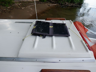
I have a Goal Zero Nomad 7 with a solar battery inserted in the pocket on the back bungeef to the sliding panel above the companionway door. I also have a Goal Zero Nomad 14 mounted on a bracket I made that hangs off the back of the boat. The14 one get full sun since it isn’t shaded by the sail. These solar panel/batteries are used to charge my phone, iPad, camera and operate a USB fan.

This little light ring does a great job of lighting the cabin at night.


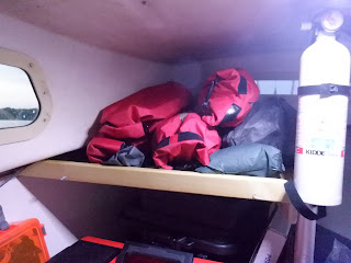
 This is a shelf I added to get my clothes off the floor. The accessory rack fits on the front of the shelf at night,

This is a telescoping pusher/grabber that has been invaluable. It’s mounted in homemade PVC pipe clips using the screws that hold the cabin roof grab bars.


Someone requested a photo of my oarlocks. As you can see, I’m using them to hold my homemade bimini.